I purchased a Garmin 60Cxs from Cabela's (http://www.cabelas.com) a week ago. Having already studied the users manual extensively (downloaded from Garmin's website, http://www.sirf.com/products-ss3.html. No doubt about it, it is very fast. If it has had a recent "fix" (less than a day old), it can lock on the satellites in about one second.
The slide show is just a few screen shots, this is not meant to be an exhaustive description of the 60Cxs, but rather to see if some claims made for it have merit. The short answer is yes, this is a dramatic improvement in nearly every respect from any GPS I have previously owned and could probably replace every one except the RINO 120's that have radios built in. You see, until now, each GPS navigator was made for a specific purpose and worked poorly (or not at all) for other uses. This is still true to a certain extent and if you do a LOT of driving on the highway, a Street Pilot is still probably better for you; but it is hard to beat this unit for most purposes.
The Garmin GPS V annoyed me for its lack of compass -- the only way to get a compass was to choose "off road navigation" at which point you also lost highway routing. The 60Cxs has highway routing AND compass all at the same time (different screens of course); and even while watching the compass, which is what I usually have on display, turn instructions will still pop up.
My Garmin Legend is probably my favorite outdoor GPS; very compact, batteries last a long time, and the screen is finely detailed with superb outdoor features. The new 60Cxs is even more detailed, batteries still last a long time, and all of the desireable features of the Legend are retained -- compass with either course (good for boating) or bearing (good for hiking) indicators.
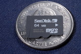
 I ran out of memory quite often on the GPS V. This is unlikely to be a problem for any of the "x"
series GPS that use a mini-SD flash memory card.
Loading maps into the GPS V (or Legend or any other serial-interface loading) takes a very long time, typically 45 minutes. Loading the same roads into the 60Cxs takes less than a minute.
Color screens on small devices are usually very dark. I am pleased to report that the Garmin color screens are very easy to read; highly transparent where they need to be transparent. I have not tinkered with these photographs other than to ensure that the full brightness range is indeed available; I have not done any tricks such as masking just the display and brightening it. What you see is what it looked like when I took the photo. The sample photos on Garmin's website look decidedly "processed".
This is my first foray into the digital compass arena. It's pretty slick and allows for a neat trick: projecting a waypoint just by sighting along a bearing and guessing at a distance.
It is also my first digital barometer. I suppose the only time you'd need barometric altitude is when you are under rain forest and the GPS might not work, you still have compass and barometric altitude. When GPS *is* working, you calibrate the barometer from the satellites and that gives you a chart-recording barometer useful for weather-guessing in the mountains. The official blurb says that the barometric altimeter allows for extremely accurate elevation; that seems to require some unlikely factors: an accurately known elevation reference, a barometric pressure at that reference location, followed by using that information to calibrate your 60Cxs, and finally being near enough to the reference location that variations are unlikely. Generally speaking, however, GPS altimeters are more accurate than barometric altimeters and is one reason the FAA reportedly allows 500 foot vertical separation between aircraft using GPS, but requires 1,000 foot vertical separation between aircraft using barometric altimeters.
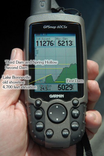
The elevation profile is very interesting; at least if you live where some elevation profile actually exists. I'm not yet sure where it would be useful, but in the example shown, it conveys the riverbottom profile of Logan Canyon quite well and easily shows the level sections of the canyon where small dams back up the water. I suppose you could use it to validate the course of a ditch or canal before digging it; you should see a steady downward profile as you walk or drive the course of the canal from the headgate. Obviously any accurate GPS can do the same thing but it will take a long time; the graph is very quick.
The data for the elevation profile is stored in the track log I suppose, what it means is that you can zoom in and out on the elevation profile, change type, and scroll horizontally on the profile beyond the data that is currently visible. As you scroll, the cursor will report the time or distance (x axis) and elevation or barometric pressure (y axis).
Other tidbits -- the external power and serial data socket is the same as for GPS III+ and GPS V, so if you have had either of these and still have the cable, you are in luck.
