A Review of the Garmin GPS III+™
Global Positioning Satellite (GPS) Receiver
Photographs and Descriptions by a satisfied owner
of one of these units.
Official Website: Garmin Corporation.
Founded in 1989 producing GPS receivers for aviation, with embedded
IFR, Jeppeson charts. Now offering a galaxy of about 33 products
well suited for hiking, boating, bicycling and flying. The official
website is excellent, complete with PDF format Operator Manuals
and digital protocol formats for programmers to make their own
interfaces.
Back to Michael Gordon's GPS website
Michael Gordon's First Impression of
the Garmin GPS III+, features and operating details.
|
Garmin
GPS III PLUS Photographs and stories |
(Click on photographs for enlargements)
"Men don't need no stinkin' directions!"
(To paraphrase Cheech and Chong)
 (Photo:
Sevier Dry Lake Bed, Utah) Men in particular are famous
for not wanting to appear to be navigational idiots. Consequently,
men usually resist obtaining directions, I know it has been a
long time since I asked anyone! After all, what do you get? "Go
down the road a ways to the third right turn then keep going until
you pass the old Hansen place. Watch for the big oak then turn
left. You can't miss it." Oh yeah? Watch me! I'll be
lost before the third turn because I'm counting driveways but
whoever gave me directions did not (or vice versa).
 (Photo:
a clickable composite photo, highway 99 between Sacramento
and Fresno. The GPS is showing where I am -- coming up on Chowchilla
-- it is showing that I have 36 miles to go before the next waypoint
and it is going to take 31 minutes to get there. In the background,
perfectly flat and featureless country described in the next paragraph.
Imagine getting off the freeway and driving this country at night!
Talk about getting lost...)
To the rescue comes GPS! Besides telling you what a man has
always wanted to know (where I am, where it is), the map is extremely
handy for showing HOW to get there. (Most of the time, anyway.
Occasionally subtle problems arise -- I was in Sacramento and
drove to an intersection shown on the GPS -- but it was not an
intersection at all, Elkhorn boulevard was thirty feet in the
air over my head! The road I was on went under Elkhorn
and did not intersect.)
Can you get lost in broad daylight? Yes! I
made a wrong turn south of Fresno and took route 43 south instead
of route 41. Fortunately for me, GPS discovered my error. With
the built-in map, I found a road crossing over to route 41, and
as a bonus, when I got to route 41, the GPS showed that I needed
to make a right turn -- all without looking at road signs which,
for the most part, are non-existent out in the country. A co-worker
made the same mistake, but without GPS, she drove for hours among
walnut and pecan orchards talking on a cellphone trying to figure
out where she was.
Had I programmed the waypoints properly, my mistake would have
been easily avoided. The correct approach is to waypoint the intersection
of Highway 99 and route 41, then place a waypoint at Hanford.
Then, just follow the arrow and watch the distance count down
to zero, turn in the direction indicated, and watch the distance
count down to zero again, and you are there.
It works in a city, too; if you have programmed a "waypoint"
for your destination, the arrow will point to it and give you
the distance. You can also program important intersections along
the way to create a "route", and some mapping software
exists that makes route-making easy as pie (DeLorme Street
Atlas®, for instance).

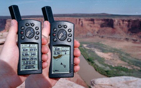
Composite photograph of a Garmin GPS III+ at Horsethief
Point, Utah. You can click on either of the GPS images to enlarge
the view.
The photos show two of the many display screens available.
On the left, the data screen; each of the six top "cells"
can be programmed to display from a dozen or so data items. In
the example, I have chosen speed, battery voltage, altitude (in
feet, but you can choose meters), sunrise, trip odometer, sunset.
You also have fixed information: latitude-longitude (or other
map coordinate system) date and time. On the right, is the map
or horizontal situation display. The dotted line shows where I
have been hiking along the edge of the cliff and the black square
is where I parked the vehicle. The fine black line is a road and
the thick black line is the Green River.
 Moving
Maps and Geographic Display. The Garmin GPS III and the
GPS III+ have built-in road maps. The "plus" version
comes with a computer cable and, if you purchase optional software,
can upload detailed maps into the GPS receiver.
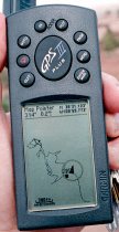
< This photo (clickable to enlarge the screen) shows some
of the useful features. It is zoomed way in, which is to say,
suitable for hiking. It shows the travels I made on foot on the
cliffs overlooking the Green River in southeast Utah. The cliffs,
rocks and occasional trees made it impossible to see where I had
parked my vehicle -- the black square. But, GPS made it easy to
"beeline" to my vehicle when I was ready to depart.
If you look closely (click on it to zoom up), the top of the
screen is showing a distance, bearing, latitude and longitude.
This means that I activated the map pointer (push on the center
rocker button). The hollow arrow at the top left is the map
pointer, and I have moved it to the farthest reach of
my hiking. You can see that it is 314 degrees, 0.2 miles from
my present position, which is marked by the black triangle.
Proceed now to:
Michael Gordon's First
Impression of the Garmin GPS III+, features and operating details.
Back to GPS main page
 (Photo:
Sevier Dry Lake Bed, Utah) Men in particular are famous
for not wanting to appear to be navigational idiots. Consequently,
men usually resist obtaining directions, I know it has been a
long time since I asked anyone! After all, what do you get? "Go
down the road a ways to the third right turn then keep going until
you pass the old Hansen place. Watch for the big oak then turn
left. You can't miss it." Oh yeah? Watch me! I'll be
lost before the third turn because I'm counting driveways but
whoever gave me directions did not (or vice versa).

