Travelog:
Story and photography by Michael Gordon.
118 Photographs from 1986.
Start the slide show by clicking on START below this paragraph. Each page includes in its title bar the file name of the photo itself for easier selection.
Each photo is clickable; clicking on the photo advances you to the next photo. Below each photo is a set of links (buttons) to advance, return, or exit the slide show. Each photo includes a button to ZOOM to a larger size.
A thumbnail gallery is available for visually selecting photos. If you choose this option, clicking a thumbnail puts you into the slide show at the photo chosen; from there the slide show proceeds with the remainder of the show.
Follow the Tourguide
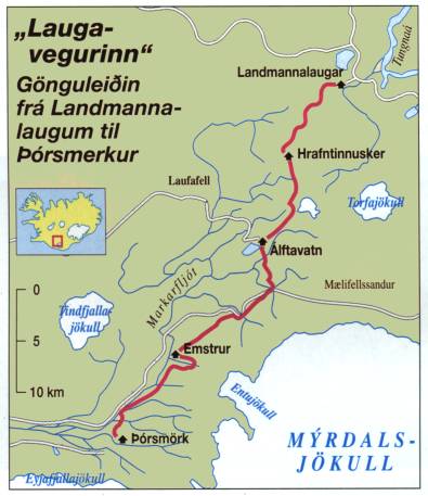
This is a slide show of a hike from Landmannalaugur southward to
Þórsmörk (Thorsmork). The first and the
fifth night are in cabins at the start and end points, three nights are
spent in cabins along the trail. The geographic location is south-central
Iceland, north and west of Myrdalsjökul (Myrdal's glacier) which
itself is south and west of the vast Vatnajökul (Vatna glacier).
On an afternoon in the summer of 1986, a group of hikers, members of
Ferðafélag Íslands, took bus to Landmannalaugur
(GPS 63°59.600 - 19°03.660) northeast from Hekla volcano. This
place is in a canyon just below a recent lava flow or hraun and forms
warm water for a bath or laug. We stayed overnight in a cabin.
F.I. maintains the trails and cabins; members pay annual dues and a
small fee for each hike. I have copied GPS from F.I. website; in 1986
GPS was a new idea and certainly no pocket GPS receivers existed.
Reference: Ferðafélag Íslands (Fer'-tha-fiel'-ag ees'-lands, Touring Society of Iceland). Their website is in the Icelandic language (Íslenskumál). Membership is rather expensive but this is the premier hiking club in Iceland. They maintain many cabins throughout Iceland and publish a beautiful annual photo journal or yearbook F.I. maintains trails and offer tourguides. High country trails should generally be hiked in late July or August; but sometimes they do this trail in the winter on skis.
Schedule of tours. Day hikes, multi-day camping/hikes are listed along with an indicator of difficulty (more hiking boots signifies more difficulty). Any hike showing 3 boots or more requires careful preparation.
Details of tours on F.I. website. Some of this information I will copy here (GPS, distances, times) in English.
The tourguide is your navigator, he is not a sheepherder. Iceland, at least in 1986, was very libertarian in the sense that you can do pretty much anything you want. They assume you will be courteous and smart and they can hardly believe they should put up a fence around Strókkur just to keep stupid tourists from looking down the borehole of a geysir. On the other hand, when I developed some blisters anyway despite my preparations, Johannes was prepared with moleskin and that kept me going on the last day of the hike. Thank you, Johannes!
On this hike, occasionally we were required to hike across snow. This is very dangerous in volcano country. Snow often melts from underneath creating caverns. If you go wandering off by yourself, you may break the roof and fall into one of these. Icelanders are extremely skilled in search and rescue but they have little respect for stupidity. Even with GPS, you still need to follow the tourguide.
Travelog:
The first day of hiking (12 kilometers, estimate 4 to 5 hours but side
trips add substantially to the travel time) involved a rather steep climb
up the face of Laugahraun and then relatively flat for a distance
until we started climbing to the top of Brennisteinsalda. The
language is descriptive; you can usually figure out from the name what it
ought to be -- Brennistein "brown stone" or sulfur-tinted stone (sulfur
has its own name, I think). Hot steam came out of the ground in many
places as we are close to the Mid-Atlantic Rift zone with intense volcanism.
You climb 470 meters today.
From Brennisteinsalda we traveled southward across relatively flat
ground, cut by little rivers, some of which had snowpacks, others steaming
hot water, some had it all. Navigation is difficult, aided by poles
in the ground or in the snow. Follow the tourguide.
We came to the small mountain Hrafntinnusker which means
"Raven black mountain" or something like that; Raven black in this
context means obsidian, or black glass. The whole mountain was
made of it -- beautiful, glossy translucent black boulders everywhere, surrounded
by steam vents of impressive proportion. We traveled across Hrafntinnusker
to a little canyon on the west of it, where we found a small glacier and
explored heat-melted caves at a place called Íshellir (ice-hole,
or ice cave). You can see in the photographs a huge cloud of steam
rising, this is probably Stórahver.
Then back to the east side where we camped in a cabin, Höskuldsskáli
(63°56.014 19°10.109). Butane stoves are accepted inside,
kerosene stoves must be burned outside. I don't think propane existed
in stove quantities at the time. Kerosene puts out a lot more heat
but it is difficult to get started. Mine was kerosene so I was outcast
with two other campers for cooking.
In the evening, people talk and sing folk songs, and while I did not understand
very much of it (despite instruction by Leo Munro, a refugee from Wales after
World War 2 came to Iceland and taught language and culture to Americans at
the Nato Base at Keflavik), but they were very friendly and made a huge impression
on me by singing a song in honor of the Heiðloa, a smart, beautiful
bird that is first to arrive in the spring and has a call that carries over
the tundra for a long distance. In winter, sometimes the radio station
broadcasts the call of the Heiðloa and makes everyone think of
spring and it is a very fine thing indeed. They sang the song for
me, since I had mentioned earlier in the day that my favorite bird of Iceland
was Heiðloa.
Language help: The Golden Plover. To pronounce the name of it, pronounce ð with soft voice, like the "th" in "mother" or "other", and the "ei" is like a long "a" as in "hay", so combine and you get hayth-loa, and by now you have noticed a resemblence to English "Heath" or "Heather" as in tundra or meadow. This bird is larger than any other plover (sandpiper) I have seen, and very smart. They will come to see what you are doing, and then they will chirp and entice you to follow away from their nest and they will do this for an unbelievably long time; I had one heiðloa escort me for about 15 minutes when I was hiking on Vogastapa near Keflavik.
On the second day we finished the high country, coming down from
a high place called Jökultungur to the north side of a beautiful
lake called Álftavatn (Alfta = Swan, vatn = Lake or water)
where we camped for the second night. Coming down from the high place
gave a fantastic view southward to the glacier Myrdalsjökull. The
drop is spectactular, 490 meters almost in one continuous descent. The cabin is located at
GPS 63°51.470 - 19°13.640.
On the third day we found dirt roads to walk along, and the hike
was 15 kilometers long. Because of the lower elevation, the ground
was covered with thin grass and tundra and for a time the sun shone upon
us and it was very pleasant. We waded through a river and the water
was extremely cold. The document for this hike warned to bring "light
shoes", but as I had translated it from Icelandic language, I was unsure
what was wanted. Now, of course, I can advise hikers that 2 millimeter
neoprene booties would be perfect, or any sort of water shoe. I had
brought "flip flops" and they would not stay on my feet in the fast flowing,
but shallow water so I walked barefoot through the ice water.
Then we hiked south through Mælifellssand to Emstrur, a district
of black dust, perfectly flat and adjacent to (northwest from) the huge
glacier Myrdalsjökul. We crossed two more rivers, but these
were on bridges, a fortunate thing considering that the water was moving
very fast and loaded with glacial silt. These rivers join and
cut a deep canyon into the soft lava and ash deposits, a canyon and river
called Markarflot, in which is also located a beautiful, secluded
spot called Þórsmörk (Thorsmork: Thor's Forest).
Anyway, we camped in a cabin at Emstrur (GPS 63°45.980
19°22.450) and in the evening, Johannes invited several of our group
to sit on a high cliff overlooking the glacier Myrdalsjökull and the
deep canyon Markarflotsgljufur. in cracks and ledges of which nest
the bird we call Fulmar.
The fourth day was the last day of hiking, another 15 kilometers.
We hiked from the cabin in Emstrur, down a steep incline which caused
one of our party to suffer from acrophobia (fear of hights) and it was with
difficulty we persuaded her down. Then we came to the trees, almost
the only trees on Iceland and very much revered. Finally, the cabin at Þórsmörk.
(GPS 63°40.960 - 19°30.890) We explored nearby interesting
places.
On the fifth day we explored around a little bit, noticing a Hringsjá
(ring-see) or "view dial" (like a sun dial) on the hilltop west of the
cabin. Several of these exist around Iceland. I'd love to have
a copy of the one on Vogastapa.